-
Category Utilities
-
Size 3.8 MB
The XGPS190 ADS-B Status Tool is a simple utility application for use with the XGPS190 GPS + ADS-B Weather and Traffic Receiver with AHRS from Dual Electronics Corp. This app shows detailed information from the XGPS190 including:- confirmation that the receiver is connected and communicating with your iOS device - whether or not the device is actively receiving an ADS-B signal- what kind of ADS-B information is being received- the number of GPS satellites in view and their signal strength- your location, or whether the receiver is still waiting for satellite information- the battery level- the charging statusInstallation of this app is optional. Languages: English Requirements: - Compatible with iPad- Requires iOS 8.0 or later- For use only with the XGPS190 receiver from Dual Electronics Corp. Support e-mail: [email protected] ADS-B Receiver web site: http://gps.dualav.com
Status Tool alternatives
HMC Crosswind Calculator
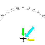
HMC Crosswind Calculator is pretty straightforward. Use the wheels at the bottom of the screen to set your heading (or expected runway heading), the wind direction, and the speed of the wind in knots. The pilots at HMC Software.
-
size 1.1 MB
FlightLink
FlightLink is the free, proprietary app that adds enhanced functionality to all Lightspeed headsets. Flightlink works seamlessly with all new Lightspeed headsets to record and playback incoming and outgoing communications. The ability to set and save other audio and operational preferences through FlightLink is only available on the Zulu PFX headset.
-
size 24.4 MB
Spin-a-Wind
Featured in Flying Magazine July 2012 8 Great Aviation Apps Reviewed favorably on AOPA Flight Planning App Roulette 20 Nov 2012Designed by an airline pilot, Spin-a-Wind calculates wind components, temperatures, altitudes and airspeeds. The headwind (tailwind) and crosswind components are based on the runway, and reported wind direction and speed. Here, you can set your display speed units (kts, mph, kph) and pressure units(inHg, hPa, mb) as well as the threshold points where the wind results turn amber (caution zone) and red (aircraft limits).
-
rating 4.55556
-
size 10.7 MB
SkewTLogPro
NOTE: 1 star reviews about No Data are out of our control. Data is pulled from NOAA. * Great for aviators, glider pilots and weather enthusiasts.
-
rating 5.0
-
size 95.4 MB


