-
Category Navigation
-
Size 160 MB
AVIATOR is the all-in-one app providing pilots with a single point of access to the independent EFB applications they already know. A common interface allows them to quickly and easily navigate between apps to streamline workflows, improve efficiency and reduce heads down time. AVIATOR customers naturally have access to Jeppesens 24/7/365 world-class support serviceAVIATOR Features: Dashboard displays key centralized information including weather and flight information Simple to use interface Easy-to-read dashboard Unified navigation menu across all EFB applications allows quick access from anywhere in the apps Powerful content manager allows viewing and annotation of up to seven PDF documents at once TripKit on Demand integration provides easy alternate source of electronic navigation charts Device to device sync allows quick and easy sharing of Flight Plans, Flight information, and Trip Kit content between devices in the cockpit Pilot Utilities: Calculator, unit conversions, timers and stop watch functionality built-in
Jeppesen Aviator alternatives
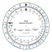
E6B Descent Planner
The E6B Descent Planner provides a fully functional circular slide rule for use in real time descent planning. Using one finger, and with a single turn of the rotating inner disk, pilots can easily perform calculations to determine top of descent distance, angle of descent, vertical descent rate required, glide ratio, maximum glide distance based on altitude, plus many other calculations that are not commonly associated with a mechanical E6B.
-
size 37.8 MB
AeroChart Asia
More than 4500 aeronautical charts of asian aerodromes (Bangladesh, Hong Kong, India, Indonesia, Japan, Macau, Malaysia, Mongolia, Philippines, South Korea, Taiwan and Thailand). AeroChart Asia is an application designed for pilots and aviation enthusiasts. Requires internet access to download the charts
-
rating 4.875
-
size 27.8 MB
AeroChart Euro
More than 13700 aeronautical charts of european aerodromes. AeroChart Euro is an application designed for pilots and aviation enthusiasts. Requires internet access to download the charts
-
rating 4.57143
-
size 31.1 MB
AeroPointer - Global Aeronautical Data for Pilots
If you are a pilot - AeroPointer is for youAeroPointer provides you with worldwide aeronautical data for over 41,000 airports and 10,900 radio navigation aids (Navaids).From the creator of Nav Trainer and Holding Pattern Trainer.-Offline access to most data even when internet is off.-Other data, such as airport charts and weather is cached for later offline view after you first access to it online.-Weather, airport charts and notams are cached for offline view once they are downloaded. Airport data:-Name, city, state and country-Local and ICAO identifiers.-FAA / NACO airport diagrams and instrument procedure charts.-Coordinates.-Radio frequencies.-Runway info.-Time zone-Current local and zulu (UTC) time.-Sunrise/sunset/civil twilight times.-METAR/ TAF weather reports.-Color-coded weather dashboard for METAR supported airports.-Notices to airmen (NOTAMs).Navaid data:-Type.-Power output.-location.-Identifier (letters and Morse code).-Time zone-Current local and zulu (UTC) time.-Sunrise/sunset/civil twilight times. Enjoy
-
size 65.8 MB


